Roman Roads Visualized on Subway Grid
I love maps. Ever since I was a kid, I would stare at them and think about what places like Copperopolis, Toad Suck, and Santa Claus look like. I mean does Santa live in Santa Claus, Indiana? I think not, but he probably doesn't live in Chicken, Alaska either....and somehow that brings me to Roman roads visualized as a subway map.
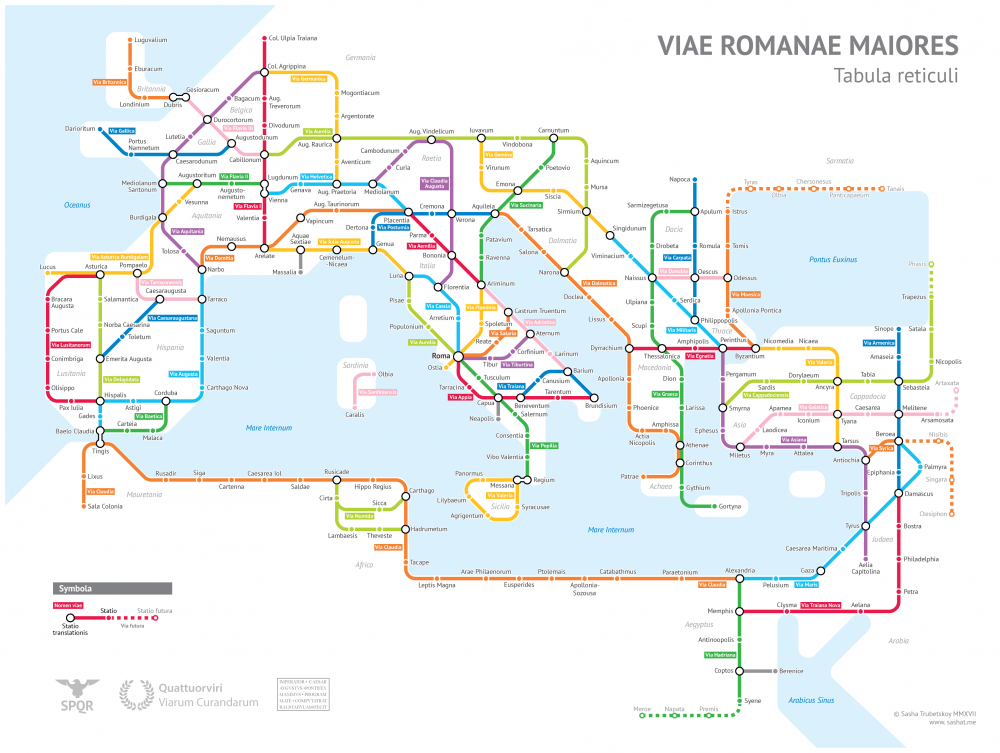 Here's the great thing about this project it was done by a college student just like you. Well, not exactly like you, but Sasha Trubetskoy is an undergrad at U. Chicago, and he created a "subway-style diagram of the major Roman roads, based on the Empire of ca. 125 AD."
Open Culture has provided a few links to larger maps for your viewing pleasure.
Trubetskov says "no sane Roman would use only roads where sea travel is available. Sailing was much cheaper and faster – a combination of horse and sailboat would get you from Rome to Byzantium in about 25 days, Rome to Carthage in 4-5 days." He also notes that money and time of year were big factors in scheduling a Roman road trip.
He did take some "liberties" with his maps leaving out some cities and minor roads.
Do you like maps? Do you want to travel back in time over some of the world's oldest roads? Can you see how this occupation (cartography) combines science and art? STEAM vs STEM? How can you combine your hobby or something you do without anyone asking and a career? Is this wise or do you think it might lead to burn out?


I really enjoy looking at colored maps, specifically of train systems, because they always include so many smaller areas and are often good ways to learn the areas around you. Just like how the BART map doesn't only have San Francisco and San Jose but it also has all of the cities going in those directions like Fremont, Union City, San Leandro. Trying to find the oldest roads would be a cool experience because I think some roads, like El Camino Real, has a lot of major historical points where you can learn a lot about California's past. it's interesting to see how science and art can be combined for careers since currently I am a psychology major who is planning on double majoring in an art and seeing that it worked out for someone is really reassuring. I want to use art to make things that could maybe advertise something and then use what I learn in psychology to capture people's attention better in the art. I think this is good and if more people had done the same thing then it would become a norm for a part of society to be learning a mix of science and art careers
ReplyDeleteThis comment has been removed by a blog administrator.
ReplyDeleteI have done a fair bit of traveling both in the US and abroad. I have had to use maps during most of my travels, and deciphering them has always been entertaining for me. Some of the hardest maps to figure out were the subway maps of London and of Tokyo as there are so many different lines and train stations. I have walked along many ancient roads in Rome, Naples, Paris, Barcelona, London, and several cities in Japan. Putting together an easily readable map is both science and art. I think that Art does have a place beside the STEM disciplines. To be able to combine a hobby and a career would be a dream come true for most, but I think that eventually it would take some of the joy out of the hobby.
ReplyDelete